File:2013 Boston Marathon bombings map.png

Original file (887 × 819 pixels, file size: 680 KB, MIME type: image/png)
Captions
Captions

|
This city map image could be re-created using vector graphics as an SVG file. This has several advantages; see Commons:Media for cleanup for more information. If an SVG form of this image is available, please upload it and afterwards replace this template with
{{vector version available|new image name}}.
It is recommended to name the SVG file "2013 Boston Marathon bombings map.svg" – then the template Vector version available (or Vva) does not need the new image name parameter. |
Summary[edit]
| Description |
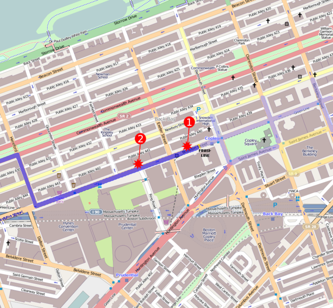
English: 2013 Boston Marathon bombings map.
The first bomb exploded at 671-673 Boylston Street, Boston, MA (42.349886, -71.078864): "MacDonald said one explosion had happened in front of the Marathon Sports store at 671-673 Boylston and the windows were blown out at a LensCrafters store, where 'the sidewalk is loaded with blood.'" 'Explosions rock Boston Marathon finish line; dozens injured', The Boston Globe. April 15, 2013 See also[1] The marathon route is shown in dark blue, the finish line in yellow, and the area for runners only is in lighter blue. The family meeting area is in lighter yellow. See Boston Marathon Course Maps. |
||||||||
| Author | Anna Frodesiak (talk · contribs) | ||||||||
| Date | |||||||||
| Source | You may find a page on the OpenStreetMap wiki page for Boston | ||||||||
| Permission (Reusing this file) |
OpenStreetMap data is available under the Open Database License (details). Map tiles are licensed under the Creative Commons Attribution-ShareAlike 2.0 license (CC-BY-SA 2.0).
|
||||||||
| Georeferencing | If inappropriate please set warp_status=skip to hide. |
Licensing[edit]
| Contains map data © OpenStreetMap contributors, made available under the terms of the Open Database License (ODbL).
The ODbL does not require any particular license for maps produced from ODbL data; map tiles produced by the OpenStreetMap foundation are licensed under the CC-BY-SA-2.0 licence, but maps produced by other people may be subject to other licences. |
|
This file is licensed under the Creative Commons Attribution-Share Alike 2.0 Generic license. | |
|
File history
Click on a date/time to view the file as it appeared at that time.
| Date/Time | Thumbnail | Dimensions | User | Comment | |
|---|---|---|---|---|---|
| current | 18:06, 17 April 2013 | | 887 × 819 (680 KB) | Apteva (talk | contribs) | route correction |
| 03:13, 17 April 2013 |  | 887 × 819 (705 KB) | Ke4roh (talk | contribs) | Add route information - marathon course dark blue, finish line yellow, runner only area light blue, family meeting area yellow | |
| 00:10, 16 April 2013 |  | 887 × 819 (712 KB) | Odder (talk | contribs) | the first blast was too far left; pictures suggest the blasts took place on the sidewalk, and not in the middle of the street | |
| 23:50, 15 April 2013 |  | 887 × 819 (711 KB) | Odder (talk | contribs) | numbers, circle => 9-pointed star, reduced size of the blast indicators per talk page comment | |
| 23:45, 15 April 2013 |  | 887 × 819 (556 KB) | Anna Frodesiak (talk | contribs) | adjust location of second blast | |
| 23:05, 15 April 2013 |  | 887 × 819 (555 KB) | Anna Frodesiak (talk | contribs) | version showing site of second blast | |
| 22:51, 15 April 2013 |  | 887 × 819 (556 KB) | Anna Frodesiak (talk | contribs) | version showing first blast site | |
| 22:46, 15 April 2013 |  | 887 × 819 (515 KB) | Anna Frodesiak (talk | contribs) | User created page with UploadWizard |
You cannot overwrite this file.
File usage on Commons
There are no pages that use this file.
File usage on other wikis
The following other wikis use this file:
- Usage on ar.wikipedia.org
- Usage on cs.wikipedia.org
- Usage on de.wikipedia.org
- Usage on el.wikinews.org
- Usage on en.wikipedia.org
- Usage on es.wikipedia.org
- Usage on fi.wikipedia.org
- Usage on fr.wikinews.org
- Usage on he.wikipedia.org
- Usage on hu.wikipedia.org
- Usage on id.wikipedia.org
- Usage on it.wikinews.org
- Usage on ja.wikipedia.org
- Usage on ko.wikipedia.org
- Usage on ms.wikipedia.org
- Usage on nl.wikipedia.org
- Usage on no.wikipedia.org
- Usage on pt.wikipedia.org
- Usage on sv.wikipedia.org
- Usage on th.wikipedia.org
- Usage on tr.wikipedia.org
- Usage on uk.wikipedia.org
- Usage on uz.wikipedia.org
- Usage on vi.wikipedia.org
- Usage on zh.wikipedia.org