File:2015-09-11 18-00-00 carte-rando-nocturne.jpg

Original file (3,240 × 5,314 pixels, file size: 6.55 MB, MIME type: image/jpeg)
Captions
Captions
Summary[edit]
| Description |
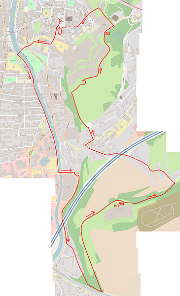
Randonnée nocturne, à Belfort et Danjoutin : plan.
This map was created from OpenStreetMap project data, collected by the community. This map may be incomplete, and may contain errors. Don't rely solely on it for navigation.
Légende de la carte :
Soutenu par la Municipalité, cet événement est organisé par le Comité Départemental de Randonnée du Territoire de Belfort (CODERANDO). Parcours long de 6,3km :
|
||||||||||||||||||||||
| Author | OpenStreetMap contributors,
|
||||||||||||||||||||||
| Date | |||||||||||||||||||||||
| Source | You may find a page on the OpenStreetMap wiki page for Randonnée nocturne, à Belfort et Danjoutin : plan. | ||||||||||||||||||||||
| Permission (Reusing this file) |
OpenStreetMap data is available under the Open Database License (details). Map tiles are licensed under the Creative Commons Attribution-ShareAlike 2.0 license (CC-BY-SA 2.0).
|
||||||||||||||||||||||
| Georeferencing | Georeference the map in Wikimaps Warper If inappropriate please set warp_status=skip to hide. | ||||||||||||||||||||||
| Camera location | 47° 38′ 18.06″ N, 6° 51′ 46.76″ E | View this and other nearby images on: OpenStreetMap - Google Earth |
|---|
Licensing[edit]
| This file is licensed under the Creative Commons Attribution 3.0 Unported license. | ||
https://creativecommons.org/licenses/by/3.0 CC BY 3.0 Creative Commons Attribution 3.0 truetrue |
File history
Click on a date/time to view the file as it appeared at that time.
| Date/Time | Thumbnail | Dimensions | User | Comment | |
|---|---|---|---|---|---|
| current | 16:53, 12 September 2015 |  | 3,240 × 5,314 (6.55 MB) | ComputerHotline (talk | contribs) |
You cannot overwrite this file.
File usage on Commons
The following page uses this file:
Metadata
This file contains additional information such as Exif metadata which may have been added by the digital camera, scanner, or software program used to create or digitize it. If the file has been modified from its original state, some details such as the timestamp may not fully reflect those of the original file. The timestamp is only as accurate as the clock in the camera, and it may be completely wrong.
| Date and time of data generation | 18:00, 11 September 2015 |
|---|---|
| Image title |
|
| Horizontal resolution | 72 dpi |
| Vertical resolution | 72 dpi |
| File change date and time | 18:00, 11 September 2015 |
| Y and C positioning | Centered |
| Exif version | 2.3 |
| Date and time of digitizing | 18:00, 11 September 2015 |
| Meaning of each component |
|
| Supported Flashpix version | 0,100 |
| Color space | Uncalibrated |
| Latitude | 47° 38′ 18.06″ N |
| Longitude | 6° 51′ 46.76″ E |
| Altitude | 364 meters above sea level |
| GPS time (atomic clock) | 16:00 |
| Geodetic survey data used | WGS-84 |
| GPS date | 11 September 2015 |
| GPS tag version | 2.2.0.0 |
| Keywords |
|
| Headline | Randonnée nocturne, Belfort&Danjoutin, 11 Sept 2015 |
| Code for country shown | FRA |
| City shown | Belfort |
| Country shown | France |
| Province or state shown | Franche-Comté |
| IIM version | 4 |
| JPEG file comment | Created with GIMP |

