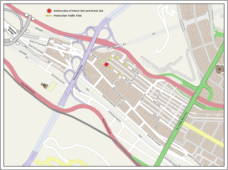
File:2015 Mina Disaster Map.svg

From Wikimedia Commons, the free media repository
Jump to navigation Jump to search

Original file(SVG file, nominally 1,305 × 974 pixels, file size: 2.79 MB)

Captions

Add a one-line explanation of what this file represents

Captions

Summary[edit]

Description
English: Map showing location of 2015 Mina Crush Disaster

Map from OpenStreetMap: https://www.openstreetmap.org/#map=16/21.4144/39.8838 and hand drawn by uploader (Carl Henderson).

Information from NYT: https://www.nytimes.com/interactive/2015/09/24/world/middleeast/mecca-mina-stampede-hajj-maps.html and Google Maps: https://www.google.com/maps/@21.4202257,39.8733885,1064m/data=!3m1!1e3
Date
Source Map from OpenStreetMap: https://www.openstreetmap.org/#map=16/21.4144/39.8838 and hand drawn by uploader (Carl Henderson).
Author OpenStreetMap & Carl Henderson

Licensing[edit]

Openstreetmap logo.svg Contains map data © OpenStreetMap contributors, made available under the terms of the Open Database License (ODbL).

The ODbL does not require any particular license for maps produced from ODbL data; map tiles produced by the OpenStreetMap foundation are licensed under the CC-BY-SA-2.0 licence, but maps produced by other people may be subject to other licences.

File history

Click on a date/time to view the file as it appeared at that time.

Date/TimeThumbnailDimensionsUserComment
current02:55, 5 November 2015Thumbnail for version as of 02:55, 5 November 20151,305 × 974 (2.79 MB)Carl Henderson (talk | contribs)User created page with UploadWizard

File usage on other wikis

The following other wikis use this file:

Metadata

Structured data

Items portrayed in this file

depicts