File:Ensanche - eixample - Barcelona.jpg
Original file (2,498 × 1,659 pixels, file size: 887 KB, MIME type: image/jpeg)
Captions
Captions
Summary[edit]
| Description |
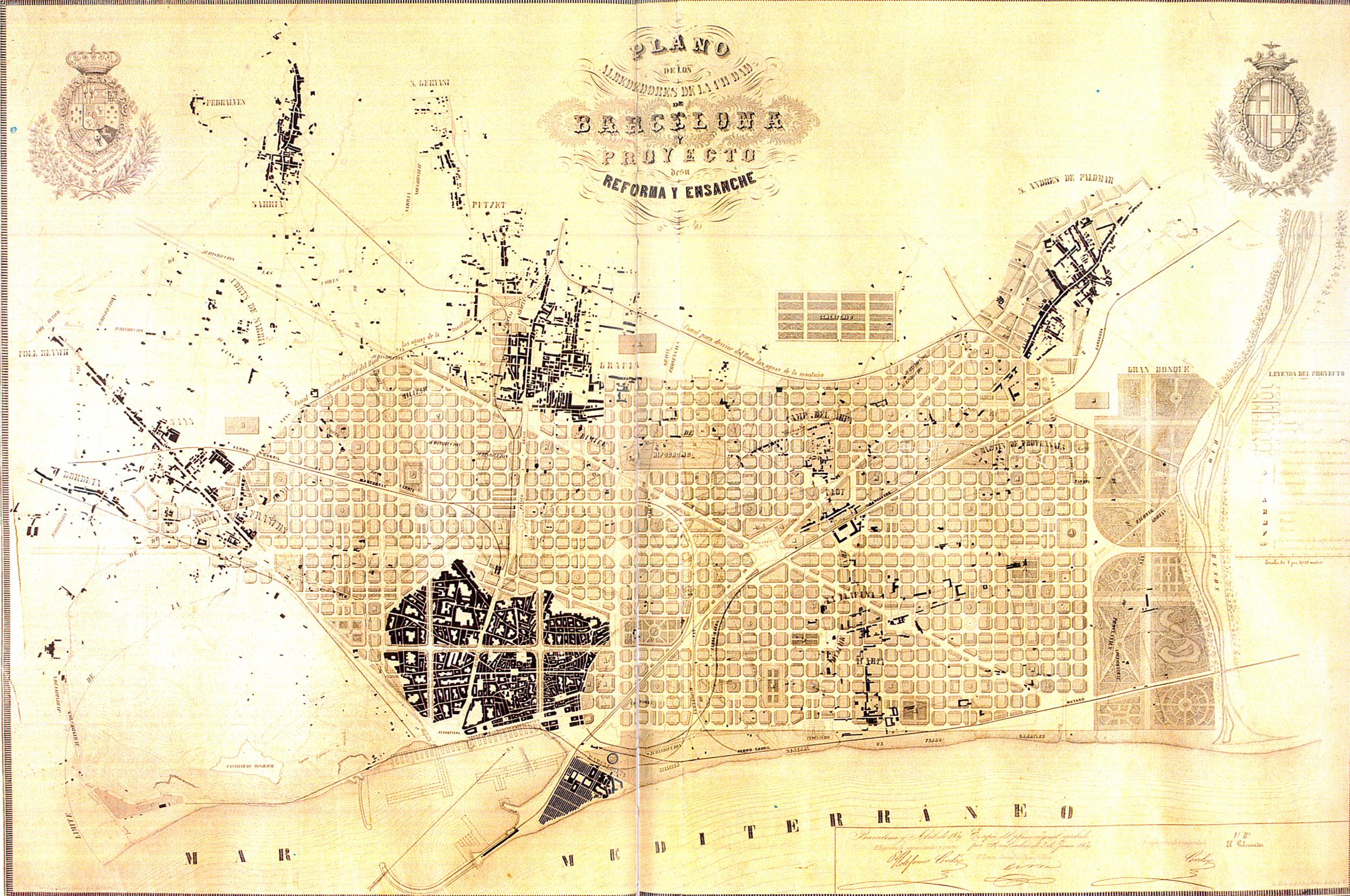
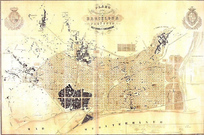
Català: Eixample de Barcelona. Pla dels voltants de la ciutat de Barcelona i del projecte per a la seva millora i ampliació, 1859.
English: Enlargement map of Barcelona. Map of the neighborhoods of the city of Barcelona and project for its improvements and enlargement, 1859.
Español: Ensanche de Barcelona. Plan de los alrededores de la ciudad de Barcelona y del proyecto para su mejora y ampliación, 1859.
Français : Aggrandissement de Barcelone. Carte des environs de la ville de Barcelone et projet d'amélioration et d'aggrandissement, 1859.
|
|||||||||
| Author | Ildefons Cerdà i Sunyer | |||||||||
| Date | ||||||||||
| Source | Museu d'Historia de la Ciutat, Barcelona. | |||||||||
| Geotemporal data | ||||||||||
| Bounding box |
|
|||||||||
| Georeferencing | ||||||||||
| Other versions |
  |
|||||||||
Licensing[edit]
|
This is a faithful photographic reproduction of a two-dimensional, public domain work of art. The work of art itself is in the public domain for the following reason:
This photographic reproduction is therefore also considered to be in the public domain in the United States. In other jurisdictions, re-use of this content may be restricted; see Reuse of PD-Art photographs for details. {{PD-Art}} template without license parameter: please specify why the underlying work is public domain in both the source country and the United States
(Usage: {{PD-Art|1=|deathyear=''year of author's death''|country=''source country''}}, where parameter #1 can be PD-old-auto, PD-old-auto-expired, PD-old-auto-1996, PD-old-100 or similar. See Commons:Multi-license copyright tags for more information.) | ||||
File history
Click on a date/time to view the file as it appeared at that time.
| Date/Time | Thumbnail | Dimensions | User | Comment | |
|---|---|---|---|---|---|
| current | 14:01, 12 April 2010 | | 2,498 × 1,659 (887 KB) | Lironcareto (talk | contribs) | Larger image. Better resolution. Category:1850 Category:Maps of Eixample Category:Urban studies and planning Category:Maps of the history of Barcelona Category:Ildefons Cerdà |
| 15:55, 14 September 2005 |  | 635 × 431 (43 KB) | Tony Rotondas (talk | contribs) | *'''Title''' {{english}} Eixample of Barcelona {{spanish}} Ensanche de Barcelona. *'''Description''' {{english}} Plan of the environs of the city of Barcelona and project for its improvements and enlargement, 1859. {{spanish}} Plan de los alrededores de |
You cannot overwrite this file.
File usage on Commons
The following 4 pages use this file:
File usage on other wikis
The following other wikis use this file:
- Usage on an.wikipedia.org
- Usage on ca.wikipedia.org
- Usage on de.wikipedia.org
- Usage on en.wikipedia.org
- Usage on eo.wikipedia.org
- Usage on fi.wikipedia.org
- Usage on gl.wikipedia.org
- Usage on he.wikipedia.org
- Usage on id.wikipedia.org
- Usage on it.wikipedia.org
- Usage on nl.wikipedia.org
- Usage on oc.wikipedia.org
- Usage on pl.wikipedia.org
- Usage on pt.wikipedia.org
- Usage on sq.wikipedia.org
- Usage on sr.wikipedia.org
- Usage on sv.wikipedia.org