File:Map of Peterloo Massacre.png
Jump to navigation
Jump to search

Size of this preview: 800 × 534 pixels. Other resolutions: 320 × 214 pixels | 640 × 427 pixels | 1,024 × 684 pixels | 1,280 × 855 pixels | 2,403 × 1,605 pixels.
Original file (2,403 × 1,605 pixels, file size: 679 KB, MIME type: image/png)
Captions
Add a one-line explanation of what this file represents
Captions
Summary[edit]
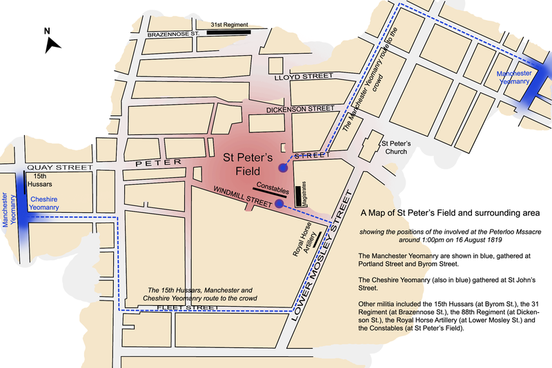
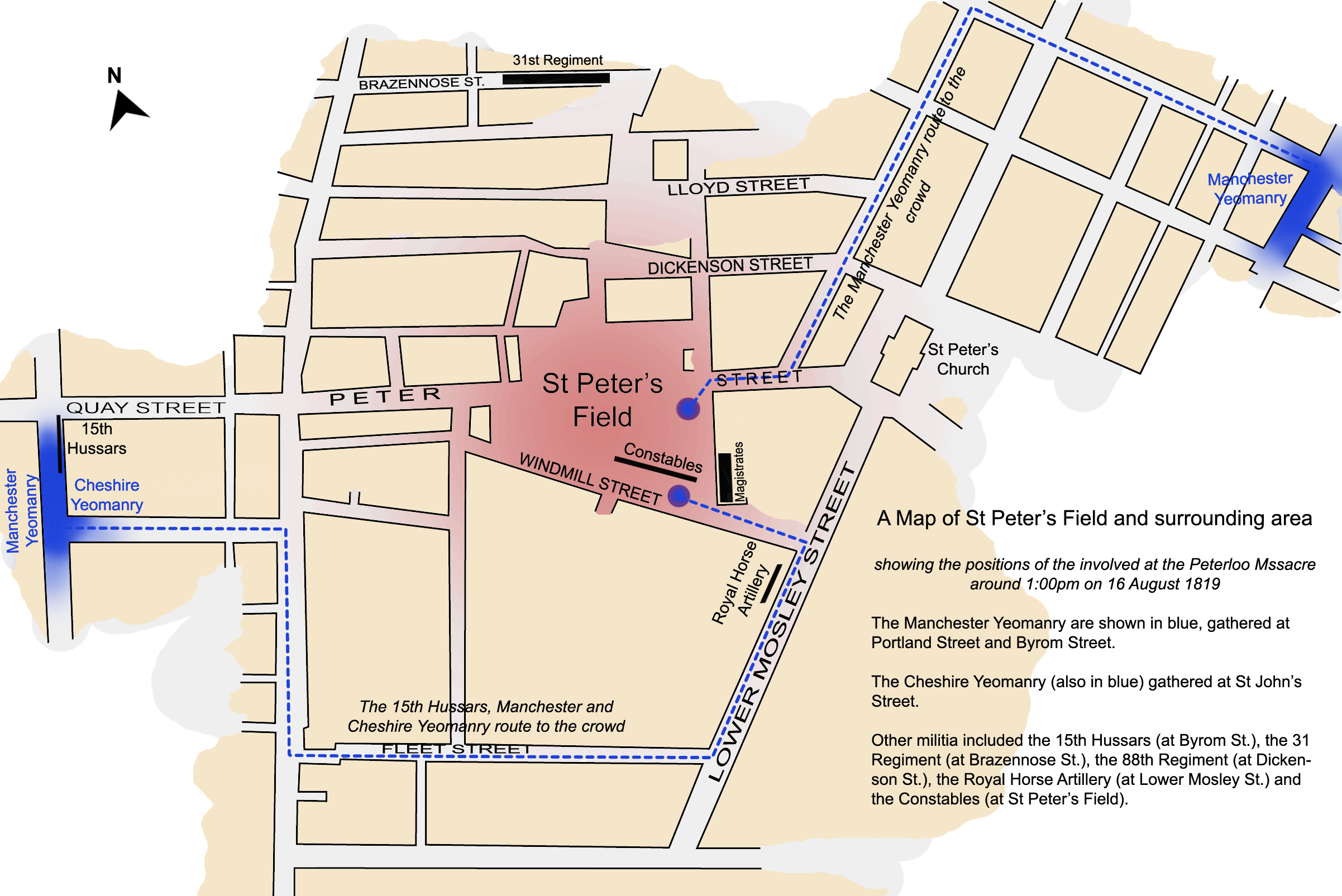
| Title | Peterloo Massacre | |||||||||
| Map legend |
Protesters Manchester & Cheshire Yeomanry |
|||||||||
| Author | Jhamez84 | |||||||||
| Date | ||||||||||
| Source | Own work by Jhamez84 | |||||||||
| Geotemporal data | ||||||||||
| Date depicted | , 13:00 | |||||||||
| Map location | St Peter's Square, Manchester | |||||||||
| Heading |
 |
|||||||||
| Bounding box |
|
|||||||||
| Georeferencing | ||||||||||
| References | based on Reid, Robert () The Peterloo Massacre, William Heinemann Ltd ISBN: 0434629014. | |||||||||
Licensing[edit]
I, the copyright holder of this work, hereby publish it under the following licenses:

|
Permission is granted to copy, distribute and/or modify this document under the terms of the GNU Free Documentation License, Version 1.2 or any later version published by the Free Software Foundation; with no Invariant Sections, no Front-Cover Texts, and no Back-Cover Texts. A copy of the license is included in the section entitled GNU Free Documentation License. |
| This file is licensed under the Creative Commons Attribution 3.0 Unported license. | ||
|
You may select the license of your choice.
File history
Click on a date/time to view the file as it appeared at that time.
| Date/Time | Thumbnail | Dimensions | User | Comment | |
|---|---|---|---|---|---|
| current | 01:45, 4 April 2008 | | 2,403 × 1,605 (679 KB) | Jza84 (talk | contribs) | {{Information |Description=A map of St Peter's Field, Manchester, England at the time of the Peterloo Massacre of 1819. This map, highlights the positions of those parties involved in the massacre as they were documented to have been at 1.00pm. |Source |
You cannot overwrite this file.
File usage on Commons
There are no pages that use this file.
File usage on other wikis
The following other wikis use this file:
- Usage on az.wikipedia.org
- Usage on en.wikipedia.org
- Usage on fi.wikipedia.org
- Usage on fr.wikipedia.org
- Usage on it.wikipedia.org
- Usage on ja.wikipedia.org
- Usage on tr.wikipedia.org
- Usage on www.wikidata.org
- Usage on zh.wikipedia.org