File:SovietInvasionAfghanistanMap.png
Jump to navigation
Jump to search

No higher resolution available.
SovietInvasionAfghanistanMap.png (689 × 446 pixels, file size: 171 KB, MIME type: image/png)
Captions
Add a one-line explanation of what this file represents
Captions

|
This military map image could be re-created using vector graphics as an SVG file. This has several advantages; see Commons:Media for cleanup for more information. If an SVG form of this image is available, please upload it and afterwards replace this template with
{{vector version available|new image name}}.
It is recommended to name the SVG file "SovietInvasionAfghanistanMap.svg" – then the template Vector version available (or Vva) does not need the new image name parameter. |
Summary[edit]
| Description |
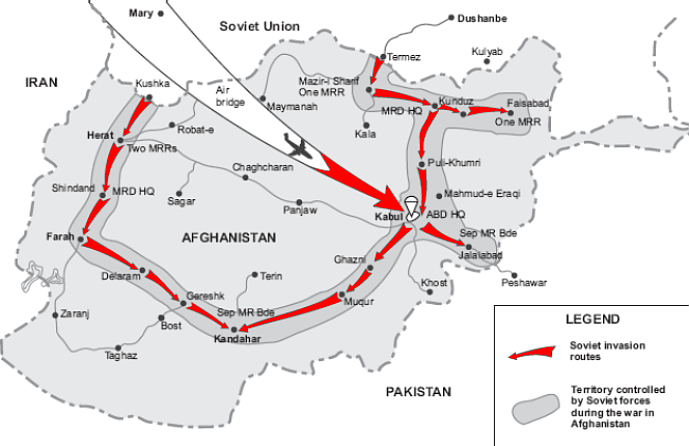
English: US-Map of Soviet Invasion in Afghanistan
|
|||||||||
| Author | Unknown author | |||||||||
| Date | Unknown date | |||||||||
| Source | http://cgsc.leavenworth.army.mil | |||||||||
| Permission (Reusing this file) |
|
|||||||||
| Geotemporal data | ||||||||||
| Bounding box |
|
|||||||||
| Georeferencing | ||||||||||

File history
Click on a date/time to view the file as it appeared at that time.
| Date/Time | Thumbnail | Dimensions | User | Comment | |
|---|---|---|---|---|---|
| current | 02:42, 25 March 2007 | | 689 × 446 (171 KB) | Wikifreund (talk | contribs) | {{Information |Description=US-Map of Soviet Invasion in Afghanistan |Source=http://cgsc.leavenworth.army.mil |Date=unknown |Author=unknown |Permission={{PD-USGov-Military}} |other_versions= }} |
You cannot overwrite this file.
File usage on Commons
The following 2 pages use this file:
File usage on other wikis
The following other wikis use this file:
- Usage on ba.wikipedia.org
- Usage on bg.wikipedia.org
- Usage on bn.wikipedia.org
- Usage on br.wikipedia.org
- Usage on ca.wikipedia.org
- Usage on de.wikipedia.org
- Usage on en.wikipedia.org
- Usage on eo.wikipedia.org
- Usage on es.wikipedia.org
- Usage on et.wikipedia.org
- Usage on eu.wikipedia.org
- Usage on fi.wikipedia.org
- Usage on fr.wikipedia.org
- Usage on he.wikipedia.org
- Usage on hr.wikipedia.org
- Usage on hu.wikipedia.org
- Usage on id.wikipedia.org
- Usage on it.wikipedia.org
- Usage on kk.wikipedia.org
- Usage on mk.wikipedia.org
- Usage on ml.wikipedia.org
- Usage on ms.wikipedia.org
- Usage on nl.wikipedia.org
- Usage on no.wikipedia.org
- Usage on pl.wikipedia.org
- Usage on pt.wikipedia.org
- Usage on ro.wikipedia.org
- Usage on ru.wikipedia.org
- Usage on sh.wikipedia.org
- Usage on sk.wikipedia.org
- Usage on so.wikipedia.org
- Usage on sr.wikipedia.org
- Usage on ta.wikipedia.org
View more global usage of this file.