File:Runö.jpg
Runö.jpg (454 × 535 pixels, file size: 42 KB, MIME type: image/jpeg)
Captions
Captions

Summary[edit]
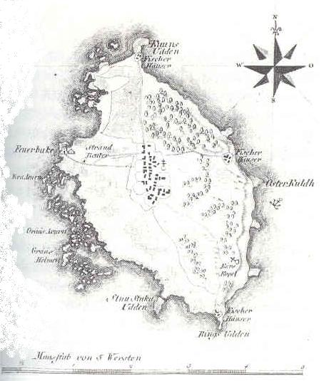
Old 18th-century map of the Estonian island Ruhnu (Runö in Swedish) from the Swedish Wikipedia. ("Karta över Runö i L. A. von Melins atlas över Livland, från år 1798.")
Originally uploaded on the Swedish Wikipedia 19 november 2004 kl.16.52 by Västgöten
Licensing[edit]
|
This work is in the public domain in its country of origin and other countries and areas where the copyright term is the author's life plus 70 years or fewer.
| |
| This file has been identified as being free of known restrictions under copyright law, including all related and neighboring rights. | |
File history
Click on a date/time to view the file as it appeared at that time.
| Date/Time | Thumbnail | Dimensions | User | Comment | |
|---|---|---|---|---|---|
| current | 21:46, 2 January 2006 | | 454 × 535 (42 KB) | Epiq (talk | contribs) | Old 18th-century map of the Estonian island Ruhnu (Runö in Swedish) from the Swedish Wikipedia. ("Karta över Runö i L. A. von Melins atlas över Livland, från år 1798.") Category:Maps of Estonia |
You cannot overwrite this file.
File usage on Commons
There are no pages that use this file.
File usage on other wikis
The following other wikis use this file:
- Usage on ar.wikipedia.org
- Usage on de.wikipedia.org
- Usage on en.wikipedia.org
- Usage on eo.wikipedia.org
- Usage on es.wikipedia.org
- Usage on et.wikipedia.org
- Usage on fi.wikipedia.org
- Usage on hr.wikipedia.org
- Usage on hy.wikipedia.org
- Usage on lt.wikipedia.org
- Usage on lv.wikipedia.org
- Usage on ml.wikipedia.org
- Usage on no.wikipedia.org
- Usage on pl.wikipedia.org
- Usage on sv.wikipedia.org
- Usage on uk.wikipedia.org
- Usage on www.wikidata.org